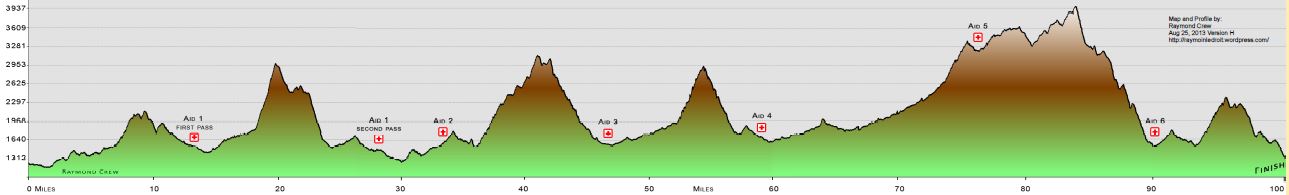
|
2009
Shenandoah Mountain 100 course
|
|
The
2009 course is the same as the 04 - 08 course's. Please do not preride
the section into the back of the Campground. To view a map of the 2002-01
course in another window click
here. (It is a 1.5 megabyte file) The 2009 course has a different
1 mile downhill onto the fireroad that takes you into the finish (verses
what is shown on the map). Something that would not even be noticed by
most on the map. We have had many conflicting reports on total elevation
change in the event. This data suggests 14,000 feet of climbing and we
have had info claiming it is closer to 12,000 ft. So strap on your gps
and tell us what you get. Thanks!!!!!!
|
| Aid Station # | Mileage |
| #1 Tillman Rd. | 10 Miles |
| #2 Todd Lake | 31 Miles |
| #3 Dowells Draft | 45 Miles |
| #4 Braley's Pond | 57 Miles |
| #5 Shenandoah Mtn Picnic Area | 75 Miles |
| #6 Todd Lake | 88 Miles |